চিত্র:1862 Johnson Map of India and Southeast Asia - Geographicus - India-johnson-1862.jpg
এই প্রাকদর্শনের আকার: ৭৯৬ × ৬০০ পিক্সেল। অন্যান্য আকারসমূহ: ৩১৯ × ২৪০ পিক্সেল | ৬৩৭ × ৪৮০ পিক্সেল | ১,০১৯ × ৭৬৮ পিক্সেল | ১,২৮০ × ৯৬৫ পিক্সেল | ২,৫৬০ × ১,৯২৯ পিক্সেল | ৩,০০০ × ২,২৬১ পিক্সেল।
মূল ফাইল (৩,০০০ × ২,২৬১ পিক্সেল, ফাইলের আকার: ২.১৩ মেগাবাইট, এমআইএমই ধরন: image/jpeg)
| এই ফাইলটি উইকিমিডিয়া কমন্স থেকে নেওয়া। সেখানের বর্ণনা পাতার বিস্তারিত নিম্নে দেখানো হলো। (সম্পাদনা)
|
| Alvin Jewett Johnson: Johnson's Hindostan or British India.
( |
|||||||||||||||||||||||
|---|---|---|---|---|---|---|---|---|---|---|---|---|---|---|---|---|---|---|---|---|---|---|---|
| শিল্পী |
|
||||||||||||||||||||||
| শিরোনাম |
Johnson's Hindostan or British India. |
||||||||||||||||||||||
| বিবরণ |
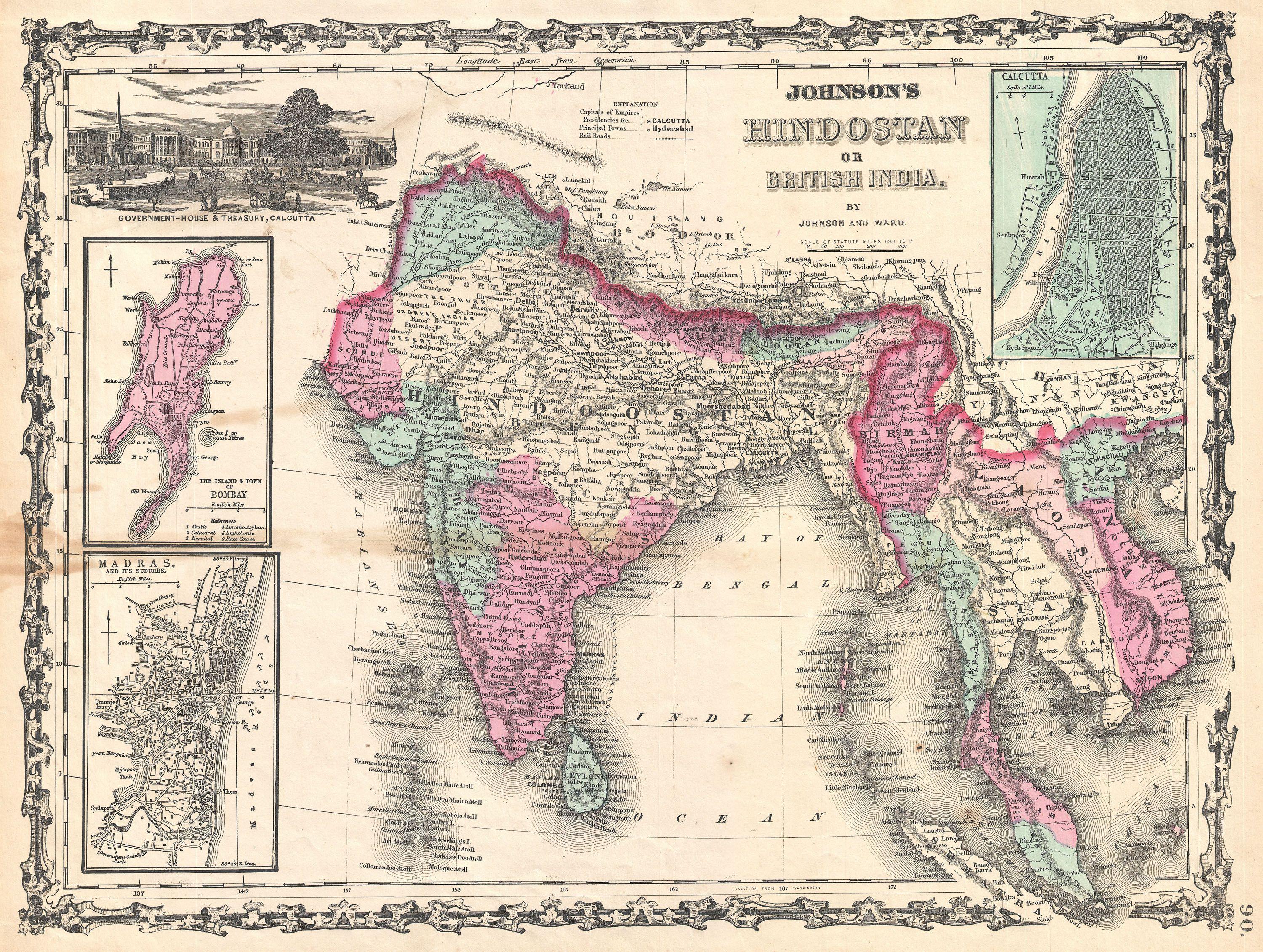
English: A very nice example of A. J. Johnson’s 1862 map of India and Southeast Asia. Covers from the Mouths of the Indus River eastward to include all of India, Burma, Siam (Thailand), Laos, Cambodia, Malaysia (Malacca) and Vietnam (Tonquin and Chochin). Also includes parts of Nepal, China, Bhutan, Sumatra and Ceylon (Sri Lanka). Offers color coding according to country and region as well as notations regarding roadways, cities, towns, and river systems. Three inset maps focus on the Island of Bombay (Mumbai), Madras, and Calcutta. An view of the Government House and Treasury in Calcutta adorns the upper left corner. Features the strapwork style border common to Johnson’s atlas work from 1860 to 1863. Published by A. J. Johnson and Ward as plate number 90 in the 1862 edition of Johnson’s New Illustrated Family Atlas . This is the first edition of the Family Atlas to bear the Johnson and Ward imprint. |
||||||||||||||||||||||
| তারিখ | ১৮৬২ (undated) | ||||||||||||||||||||||
| আকার | উচ্চতা: ১২.৫ ইঞ্চি (৩১.৭ সে.মি.); প্রস্থ: ১৬.৫ ইঞ্চি (৪১.৯ সে.মি.) | ||||||||||||||||||||||
| সংযোজন সংখ্যা |
Geographicus link: India-johnson-1862 |
||||||||||||||||||||||
| উৎস/আলোকচিত্রগ্রাহক |
Johnson, A. J., Johnson's New Illustrated (Steel Plate) Family Atlas with Descriptions, Geographical, Statistical, and Historical. (1862 A. J. Johnson & Ward edition)
|
||||||||||||||||||||||
| অনুমতি (এ ফাইলের পুনঃব্যবহার) |
|
||||||||||||||||||||||
ফাইলের ইতিহাস
যেকোনো তারিখ/সময়ে ক্লিক করে দেখুন ফাইলটি তখন কী অবস্থায় ছিল।
| তারিখ/সময় | সংক্ষেপচিত্র | মাত্রা | ব্যবহারকারী | মন্তব্য | |
|---|---|---|---|---|---|
| বর্তমান | ২৩:৫৯, ২২ মার্চ ২০১১ | | ৩,০০০ × ২,২৬১ (২.১৩ মেগাবাইট) | BotMultichillT | {{subst:User:Multichill/Geographicus |link=http://www.geographicus.com/P/AntiqueMap/India-johnson-1862 |product_name=1862 Johnson Map of India and Southeast Asia |map_title=Johnson's Hindostan or British India. |description=A very nice example of A. J. Jo |
ফাইলের ব্যবহার
নিম্নলিখিত 3টি পাতা এই ফাইল ব্যবহার করে:
ফাইলের বৈশ্বিক ব্যবহার
নিচের অন্যান্য উইকিগুলো এই ফাইলটি ব্যবহার করে:
- de.wikipedia.org-এ ব্যবহার